Date: Wed, 29 Jun 2005 18:08:56 -0400
Classification: UNCLASSIFIED
Good question. OpenMap does not seem to have a unified way to display meta
data for a point.
You may need to alter or extend an OpenMap layer and bake your own
"Identify" window.
The com.bbn.openmap.layer.location.LocationLayer (takes csv file) will
display a window containing info when you click a point and select "Show
Details" from the menu.
The com.bbn.openmap.plugin.PlugInLayer displayes a tooltip when you mouse
over a point.
The com.bbn.openmap.layer.shape.areas.AreaShapeLayer shows the point name in
the lower right corner of the window.
I have extended the AreaShapeLayer to display meta info in a window, with
field_name - field_value displayed in two columns.
It goes something like this:
<code>
// 1) capture mouseClicked event in the extended AreaShapeLayer
// ( method mouseClicked(MouseEvent me) { ... }
// 2) Get OMGraphic clicked-on
// 3) Get AppObject ( An Integer for AreaShapeLayer )
// ( Integer aligns attribute in .dbf file )
// 4) Use DbfInputStream to grab dbf file content ( see OpenMap JavaDocs )e
// ( Use the Integer to address the meta data )
// 5) Put content in someJPanelWithMyContent
// then ...
WindowSupport ws = new WindowSupport( someJPanelWithMyContent, "Attributes"
);
// window pops up.
ws.displayInWindow( x_offset, y_offset, width, height );
</code>
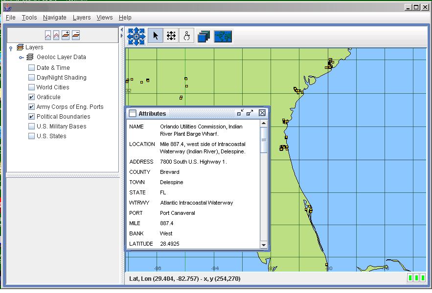
See attached screenshot showing some public points in the extended
AreaShapeLayer.
The window is the WindowSupport window containing someJPanelWithMyContent.
Have fun.
-Tom
-----Original Message-----
From: owner-openmap-users_at_bbn.com [mailto:owner-openmap-users_at_bbn.com]On
Behalf Of LT
Sent: Wednesday, June 29, 2005 1:35 PM
To: openmap-users_at_bbn.com
Subject: [OpenMap Users] Identify Operation
Hi,
I'm really new with OpenMap so forgive me if I say something stupid :)
I'm implementing a Gis application that have to manage several layers;
the functionality that I have now to develop is that of identifying the
single components in a layer;
in others words, I need a command by which clicking on a particular
element on the layer, its alpha-numerical informations are displayed.
That's like the "Identify" in ESRI - ArcView
Thanks,
Luigi
--
[To unsubscribe to this list send an email to "majdart_at_bbn.com"
with the following text in the BODY of the message "unsubscribe
openmap-users"]
--
[To unsubscribe to this list send an email to "majdart_at_bbn.com"
with the following text in the BODY of the message "unsubscribe openmap-users"]
(image/jpeg attachment: screenshot.jpg)