Date: Tue, 4 Dec 2012 12:20:59 -0500
Hello,
I've been looking into updating our map server from OpenMap 4.6.5 to use
OpenMap 5.0, as we've noticed some image anomalies have disappeared (and
I'm sure we'll see some better performance, too). There's one sticking
point that I'm trying to resolve, and I thought I'd ask for some input.
We've been using the WmsServlet to handle requests for imagery. In the
past, we'd pass in requests like the following:
http://localhost:8080/OMWMS/wms?LAYERS=shapePolitical%2Cjrpf%2Cjcib&FORMAT=image%2Fgif&SERVICE=WMS&VERSION=1.1.1&REQUEST=GetMap&STYLES=&EXCEPTIONS=application%2Fvnd.ogc.se_inimage&SRS=EPSG%3A4326&BBOX=-118.125,28.125,-112.5,33.75&WIDTH=256&HEIGHT=256
I don't think this should be too surprising. What we're seeing with this
request after making the switch to 5.0 is that whenever there is raster
imagery that extends over water, the empty space in the last tile is
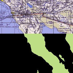
getting padded out with a black fill. For instance, a tile like the one
shown here, where the raster imagery at the top in California and Mexico is
fine, but the water around the country shape imagery in the Baja is black.
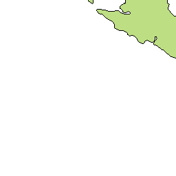
The next tile to the South of this returns to normal, with the shape layer
being rendered with a white background, as shown in the second image.
It appears that to some degree this is a problem with transparency. In the
request I shared, you'll notice that there are no BGCOLOR or TRANSPARENCY
parameters. If TRANSPARENCY is set to TRUE, then the image will display as
above (ignoring the BGCOLOR property if it is set). Supplying just BGCOLOR
essentially fixes the problem. I'm wondering if there is a way to maintain
the TRANSPARENCY setting without displaying the black background?
I've checked a few things trying to troubleshoot this: selected = false in
the OMRasterObject, and the 'finer' logging flag is not set (mentioned in
the "Border around OMRaster object" thread:
http://openmap.bbn.com/mailArchives/openmap-users/2012-06/6920.html). The
country shape file renders first, and the background is white until the the
raster imagery is rendered. I also tried reverting the
BufferedImageRenderPolicy to the StandardRenderPolicy, as I noticed it was
handling the graphics object rather differently. Still the same.
We can probably get by with specifying a background color if we need to,
but I'd like to make sure I understand this issue better and see if there's
a fix before I make a recommendation about upgrading.
Thanks,
Daniel Hale
--
[To unsubscribe to this list send an email to "majdart_at_bbn.com"
with the following text in the BODY of the message "unsubscribe openmap-users"]
(image/gif attachment: 0F179250.gif)
(image/gif attachment: 0F071906.gif)