Date: Thu, 17 Feb 2011 16:21:29 -0600
I have an application using OpenMap that serves up CADRG data rendered
by com.bbn.openmap.layer.rpf.RpfLayer using
com.bbn.openmap.image.MapRequestHandler. This has been in use for a
number of years.
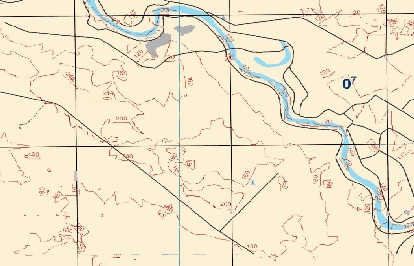
We have a new customer that has brought a new set of CADRG files. The
charts represented within this dataset include thin grid lines that fade
in and out across the rendered image, even when the requested scale is
the same as the map. Attached is an example of the rendered map. I
have tried requesting JPG, PNG, and GIF formats without any noticeable
difference. I have also tried turning on the doAntiAliasing flag in
ImageServer with no effect.
My customer has indicated that they use this same series of chart data
with another application without displaying this artifact. Of course
they are unable to share the application they are using, or show it to me.
Is there another (free) viewer of CADRG files that I can point at this
data to verify that the problem isn't with the source data?
Is there a property I can adjust within OpenMap to increase the quality
of the image?
Thanks in advance for any help.
Cheers!
Steve Tarter
--
[To unsubscribe to this list send an email to "majdart_at_bbn.com"
with the following text in the BODY of the message "unsubscribe openmap-users"]
(image/jpeg attachment: MapSample.jpg)